Biodiversity
From Living Building Science
Contents
Overview
The purpose of this subteam is to monitor and analyze biodiversity around the Kendeda building and observe different factors that affect wildlife on campus.
For the Fall 2020 semester, we have chosen to focus our efforts on birds. Through bird collision monitoring as well as AudioMoth data, we planned at looking at the current status of the bird population at Tech as well as the different factors affecting it.
Fall 2020: Bird Collision Monitoring
Birds are an important element of their respective environments. In addition to the intrinsic significance as well as the cultural value that birds possess, they play a vital role in regenerating habitats by pollinating plants and dispersing seeds. Birds control insect and rodent populations, reducing damage to crops and limiting the transmission of diseases. Unfortunately, there collision with windows poses a great threat to these birds. One-third of all bird species in the United States fall victims to bird collisions. It is the second greatest source of mortality due to human action behind domestic cats. If no action is taken to prevent bird collisions, this will result in a significant decrease in bird populations that will ultimately negatively impact the surrounding community as a whole. As part of Kendeda’s effort to be eco and wildlife-friendly, it makes use of bird-safe glass to help undermine this issue. One third of Kendeda’s windows are bird-safe, and that is predominately at the west side of the building, as opposed to the east side’s windows being non bird-safe. Knowing this, we wanted to see if these bird-safe windows were actually as effective as they claim to be. As such, we wanted to answer the question: “How effective are Kendeda’s bird-safe windows at preventing bird collisions as compared to non bird-safe windows at Kendeda and other buildings on campus?”
Methods
Every weekday around 6:45-7AM beginning 10/5/2020 and ending 11/17/2020, we searched the area around the Kendeda, ISYE, and Price Gilbert buildings for any dead or injured birds. It is important to search up to 30 feet from the building and in any plants, as injured birds may take shelter there. Any birds found are photographed and logged in our iNaturalist project (titled "Bird Collisions GT VIP") and on the Georgia Audubon bird collision map. If any injured birds are found, we would contact Adam Betuel who will arrange transportation to a rehab facility. Birds that we find are also stored in a freezer until they can later be deliver to Adam Betuel.
We got in contact with facilities to get their assistance with recording bird collisions, since they would be able to observe occurrences that we might have missed, picked up before we got to the scene, or happened at times outside our monitoring period. Facilities agreed to notify us of such events by email and were continuously doing so throughout the semester. Their notifications would include a picture of the bird collision, its location, the time that the collision occurred at, and sometimes the species if they were able to identify it.
In addition to our own recordings of the bird strikes, we were also given access to the Georgia Audubon Map of bird collisions around the Georgia Tech campus to add our observations in. We used the map for both recording collisions as well as analyzing previous collisions to get a more accurate representation of bird strikes around campus.
We created an iNaturalist project to maintain our observations in. For each observation, we included the time, place, and species of bird along with a picture of the dead bird. We also created a pamphlet that included information about bird collisions and our own project. We called on readers to help out by sending any bird strike they encounter to our email or uploading it directly to our iNaturalist project. We shared the pamphlet with several organizations, and we received replies from Tech4Wildlife and HumaniTech saying they would pass it along to their members. BBUGS also included our message in their weekly newsletter.
Findings
From 10/5/2020 until 11/17/2020, we have recorded 7 different bird collisions on campus both from our own observations and those notified to us by facilities:
| Date | Species | Location |
|---|---|---|
| 10/02/2020 | Swainson's Thrush | South Side Boggs Building |
| 10/12/2020 | Waterthrush | Front Entrance of Price-Gilbert Library |
| 10/13/2020 | Gray Catbird | Hefner Building |
| 10/15/2020 | Wood Thrush | East Side of Kendeda Building |
| 10/21/2020 | Wood Thrush | Coon Building |
| 10/22/2020 | Yellow-bellied Sapsucker | M.S.& E. Building |
| 10/23/2020 | Wood Thrush | IBB Building |
All of these collisions are significant, but perhaps the most significant observation is the bird collision that occurred near the Kendeda building. This was the first bird collision that had occurred near Kendeda since its opening. At first, this might seem disappointing as it establishes that bird strikes could occur at buildings with bird-safe windows. However, upon further investigation it could be deduced that this collision was not with bird-safe glass but with the regular glass. Kendeda makes use of bird-safe glass, yet it is not completely covered with such glass. The whole east side of kendeda incoporates non bird-safe glass; that was in fact the place at which the bird collision occurred at. This observation does not undermine the importance of bird-safe windows, but strongly reinforces the importance of these windows at their usage throughout the building and not just part of it.
Looking at the places where these collisions occurred, several common factors can be identified that could lead to such strikes. A majority of collisions probably occurred due to the reflection of vegetation on the glass. In addition, most collisions were next to trees. Others occurred due to transparency of the glass.
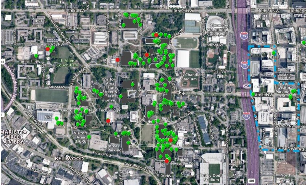
Through the Georgia Audubon map (pictured above), we were able to record these observations as well as analyze previous bird strikes . The three most common identified species found were the American Robin, Ovenbird, and Wood Thrush.
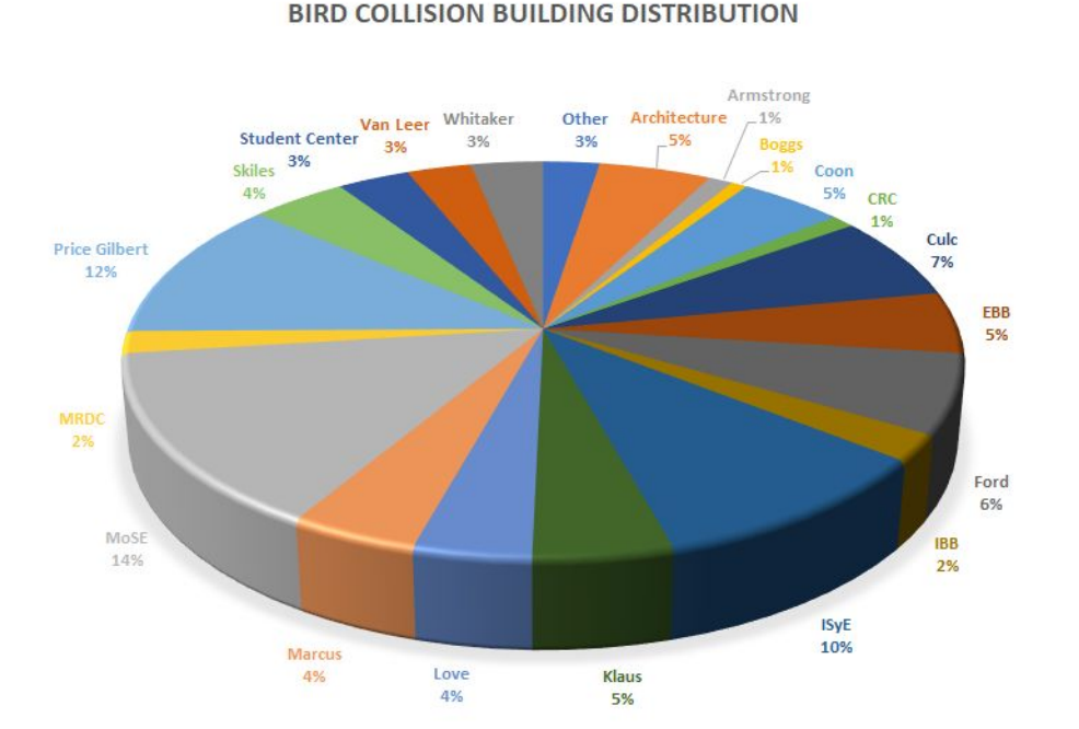
We have also made a pie graph (included above) of the buildings where bird collisions occurred. The top three building were found to be MoSE, Price Gilbert, and ISyE. Looking more closely at these buildings, they all share common characteristics of high window coverage as well as reflection of surrounding greenery.
Conclusion and Future Research
As no collisions have been observed on the side of Kendeda with the bird safe windows, we can conclude that these windows are effective at preventing bird collisions. Furthermore, they prove to be a good alternative to the traditional windows across campus. In future semesters, the team can continue to monitor bird collisions on campus. However, figuring out where bird collisions occur and why they occur is only a beginning step. Different methods of reducing and preventing bird collisions can be studied and tested. The team can continue to spread awareness about bird strikes, promote the team, and inform people about ways they can help reduce occurrences of bird strikes. Additionally, the team can expand their focus to other wildlife topics and biodiversity projects on campus. We plan to continue with our analysis of the AudioMoth data as well as explore other fields such as the ones mentioned below.
Spring 2021: Wildlife Biodiversity
Background and Purpose
The Eco-Commons consists of a designated area on campus that intends to create more expansive green space on campus and minimize runoff. It was previously a normal parking lot, which was converted into the Eco-Commons. In addition to the Eco-Commons, there is also the Kendeda Building which aims to be self-sustainable and promote eco-friendliness across campus.
Our interest in wildlife in and around the Eco-Commons stems from it being a newly built locale for animals to find shelter, live in, and roam, all within the confines of the Georgia Tech campus. It is vital that this area succeeds in what it aims to do, which is why we are monitoring the biodiversity around the area. We hope to see if the construction of the Eco-Commons is effective in one of its many goals, which is to create a friendly place for animals to live in.
Methods
In order to find wildlife we used cameras that were motion activated and placed them in a few areas in and near the EcoCommons. Cameras were located in the EcoCommons, behind MoSE, and in the wooded area behind the MRDC. The cameras were set up on sturdy trees and locked to discourage tampering. They were put up for a week, checked videos, and we decided if they should stay or be moved. A camera would stay if it captured wildlife and minimal people activity. Cameras would be moved if it captured only human activity.
To analyze our findings we used Simpson Diversity Index (SDI). This helped us to identify the amount of diversity our cameras captured. The overall diversity was the combination of all the data we collected with the cameras. The SDI compares the relative diversity of each site. The results of these equation are on a scale from 0 to 1. A high score means high diversity and a low score means low diversity.
Results
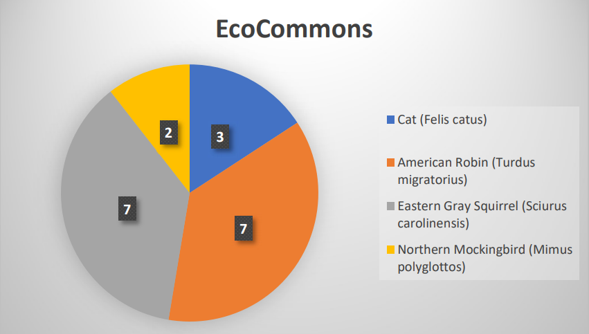
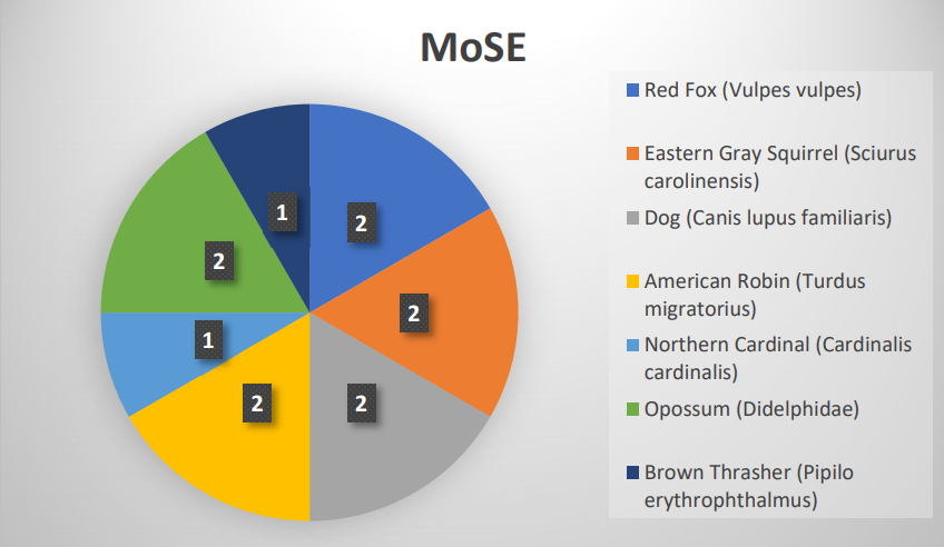
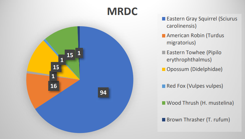
In the EcoCommons, there was a total of 19 total observation, 4 different species and a SDI of 0.731. MoSE had a total of 12 total observation with 7 different species and a SDI of 0.924. In MRDC, there was a total of 143 observations, mostly of squirrels, with 7 different species and a SDI of 0.537.
Discussion
The MRDC location had significantly more observations than the other two locations at 143 total observations. MoSE, on the other hand, had only 12, which was the least amount of total observations. In terms of SDI, MoSE had the highest SDI at 0.924, meaning it had the highest level of biodiversity among all 3 locations. MRDC, in contrast had the lowest SDI at 0.537, because, even though it had the most total observations, a significant majority of those observations were the same squirrel species. In summary, MoSE had the smallest amount of observations, but the highest level of biodiversity and MRDC had the highest amount of observations, but the lowest level of biodiversity. Compared to the other locations, the EcoCommons had less species diversity than MoSE and less total observations than MRDC. Looking into the reasons for why this was, it was found, looking at various literature sources, that factors such as landscape composition and human interaction may have played major roles in deterring wildlife from making habitats in the EcoCommons. Mammals prefer more secluded, highly wooded areas with minimal to no urban patches in the surrounding areas. The EcoCommons, on the other hand, receives high levels of human traffic and does not have densely concentrated forests and flora. One of the limitations with our project were that the trial period for learning how to use the cameras made us lose out on some potential footage due to learning how the cameras functioned. Another limitation was that the cameras were only checked once week due to each group member's schedules and therefore, if a spot where a camera was did not get much good footage, then we would not be able to change the location or check if the camera was working properly until we checked it the following week. A final limitation we identified was that due to large amounts of human activity going through locations such as the EcoCommons, we were not able to use some footage because humans were caught in the video, which made it unable to be used.
Future Work
Going into next semester, we want to use the knowledge we gained from the last couple of months and go work at a deeper level. We finally figured out great locations where to place cameras, how to use them, and general debugging methods, which will save us a lot of time in the future. With this saved time, we are looking forward to doing more proper data analysis on what we find from the cameras. In addition, we also aim to expand into other forms of biodiversity, especially on a microscopic scale. We realize as a team that biodiversity does not just exist on a macroscopic scale, therefore we want our project to be reflective of all forms of biodiversity. This is why we have made plans on how to address the field of microbial biodiversity, where we will most likely study soil samples across different parts of campus. Overall, we are truly looking forward to what we can do in the future.
Spring 2022: Bird Biodiversity
Background
The Eco-Commons consists of a designated area on campus that intends to create more expansive green space on campus and minimize runoff. Our interest in wildlife in and around the Eco-Commons stems from it being a newly built locale for animals to find shelter, live in, and roam, all within the confines of the Georgia Tech campus. In this research, we aim to look study and observe the various bird species found in and around the Eco-Commons. In doing so, we asked the question: “How does the wildlife biodiversity of the EcoCommons now compared to before it was built?”
Methods
To observe and document bird diversity, observers would walk around the EcoCommons and look for birds. The findings were then inputted to the Georgia Tech Campus hotspot on eBird to document findings. Along with visual inspections, audio recordings were taken using AudioMoths. Three were set up within the EcoCommons to record bird sounds. With these recordings, a bird sound identifier can be crafted to quickly identify birds in the area based off their calls.
Results
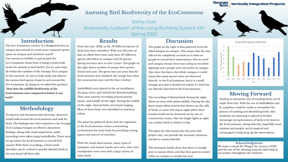
From the start 2022, so far, 70 different species of . birds have been identified. With over 20 years of data on eBird there have only been 107 different species identified on campus with 24 species having not been seen in over 5 years. The graph on the right shows number of unique bird species found each year. The green bars are years that the EcoCommons were finished, the orange bars show the construction year, and the blue is before. AudioMoths were placed in the art installation, the grass circle, and behind the Keneda building. They were actively recording around sunrise, sunset, and middle of the night. During the middle of the night, diurnal birds were heard singing. Most of these birds were identified as american robins. The plant list gathered shows that the vegetation in the EcoCommons creates a welcoming environment for most birds by providing nesting spaces and sources of nutrition. With the visual observations, many types of immature and mature hawks were seen. Also a few woodpeckers were seen with a large variety of other birds.
Discussion
The graph on the right is data gathered from the eBird hotspot on campus. This means that the data will not be completely accurate as it relies on people to record their observations. Due to covid and campus closure there was a drop in recorded sightings since people were not active on campus. Also since the data is the whole campus, it could mean that many species were not observed directly in the EcoCommons, but it is a small enough area that it should not matter if a bird was not directly observed in the EcoCommons. The recording of diurnal birds during the night shows an issue with urban wildlife. During the day, there many urban sounds that drown out the calls of birds, so some will sing at night where their sounds would not be drowned out by cars or construction noises. Also the bright lights at night can confuse birds to think it is day. The plant list data means that this area with proper care, can provide the necessary elements needed to sustain bird life. The immature hawks show that there is enough prey to sustain them, and that their parents nested either on campus or nearby last year.
Moving Forward
Finding an automatic way of tracking birds can be made from this. With the use of AudioMoths and R, a pipeline could be made to streamline the process of tracking and identifying birds. Also nestboxes are planning to placed to further encourage new generations of birds to be born in the EcoCommons. Along with this, hopefully more students and people can be inspired and encouraged to help keep up the observations.
Fall 2022: Mammal Biodiversity
Introduction
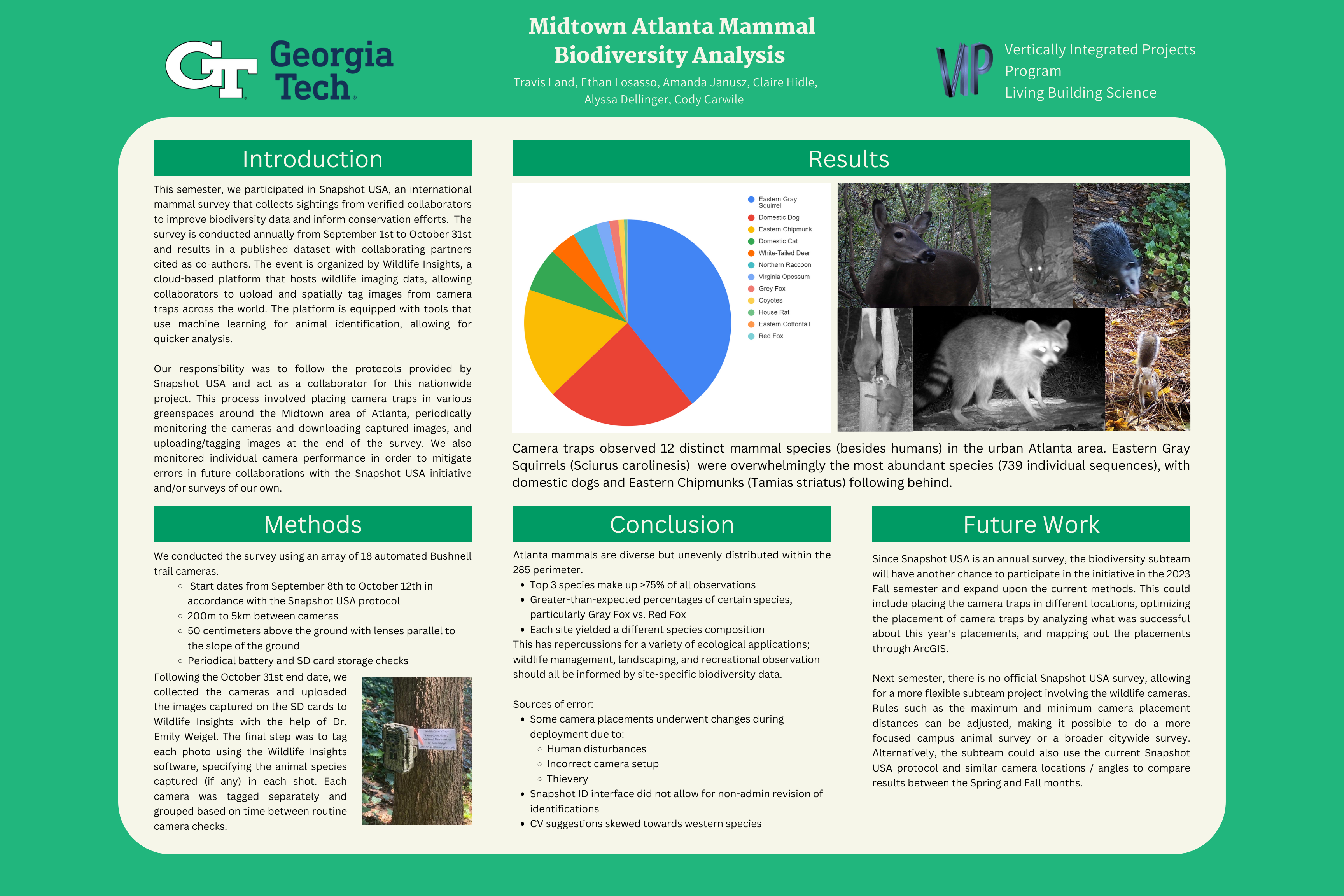
This semester, we participated in Snapshot USA, an international mammal survey that collects sightings from verified collaborators to improve biodiversity data and inform conservation efforts. The survey is conducted annually from September 1st to October 31st and results in a published dataset with collaborating partners cited as co-authors. The event is organized by Wildlife Insights, a cloud-based platform that hosts wildlife imaging data, allowing collaborators to upload and spatially tag images from camera traps across the world. The platform is equipped with tools that use machine learning for animal identification, allowing for quicker analysis.
Our responsibility was to follow the protocols provided by Snapshot USA and act as a collaborator for this nationwide project. This process involved placing camera traps in various greenspaces around the Midtown area of Atlanta, periodically monitoring the cameras and downloading captured images, and uploading/tagging images at the end of the survey. We also monitored individual camera performance in order to mitigate errors in future collaborations with the Snapshot USA initiative and/or surveys of our own.
This project most directly relates to the place petal of the Living Building Challenge Sustainability Petals. The Kendeda Building is located on Georgia Tech's campus, which is in the heart of Atlanta. We recognize the importance of our place within the city, so the range of our observations were not exclusive to the Kendeda Building and Georgia Tech. Many of our camera traps were set in larger greenspaces in Midtown area, such as Piedmont Park, Ansley Park, and Morningside Preserve.
Methods
We conducted the survey using an array of 18 automated Bushnell trail cameras, with start dates from September 8th to October 12th in accordance with the Snapshot USA protocol. The distance between cameras could not be closer than 200 meters, and could not be further than 5 kilometers. Each camera was to be attached 50 centimeters above the ground with lenses parallel to the slope of the ground. The team members performed periodical battery and SD card storage checks.
Following the October 31st end date, we collected the cameras and uploaded the images captured on the SD cards to Wildlife Insights with the help of Dr. Emily Weigel. The final step was to tag each photo using the Wildlife Insights software, specifying the animal species captured (if any) in each shot. Photos were often grouped in sequences if they were taken within one minute of each other. This helped avoid the issue of having to tag thousands of photos individually. Each camera was tagged separately and grouped based on time between routine camera checks.
Results
Conclusions
Future Work
Since Snapshot USA is an annual survey, the biodiversity subteam will have another chance to participate in the initiative in the 2023 Fall semester and expand upon the current methods. This could include placing the camera traps in different locations, optimizing the placement of camera traps by analyzing what was successful about this year's placements, and mapping out the placements through ArcGIS.
Next semester, there is no official Snapshot USA survey, allowing for a more flexible subteam project involving the wildlife cameras. Rules such as the maximum and minimum camera placement distances can be adjusted, making it possible to do a more focused campus animal survey or a broader citywide survey. Alternatively, the subteam could also use the current Snapshot USA protocol and similar camera locations / angles to compare results between the Spring and Fall months.
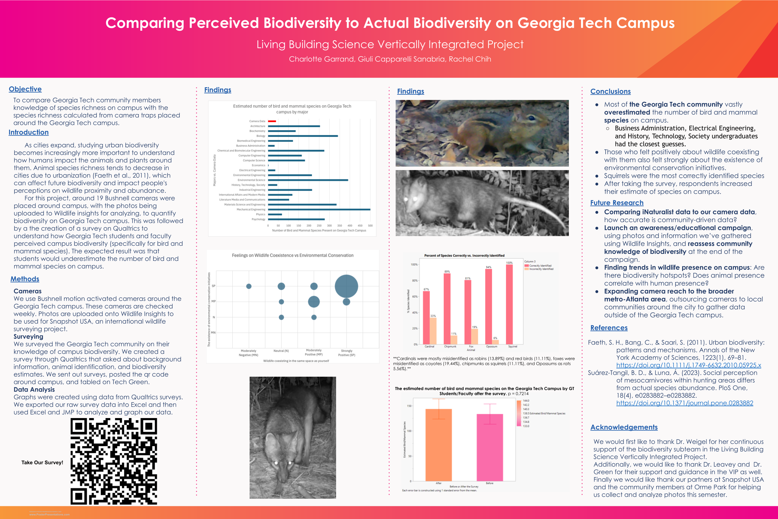
Fall 2025: Community Estimates of Biodiversity
References
Article describing Kendeda's bird-safe glass:
Edelstein , Ken. Kendeda Building's Bird-Safe Glass: Small Step in 'Shockingly Huge' Issue. 1 May 2019, livingbuilding.kendedafund.org/2019/04/26/kendeda-buildings-bird-safe-glass-shockingly-huge-issue/.
Georgia Audubon Map:
National Audubon Society's Mapping Center, audubon.maps.arcgis.com/home/index.html.
Project Safe Flight describing bird collision monitoring around Atlanta:
“Project Safe Flight.” Georgia Audubon, www.georgiaaudubon.org/project-safe-flight.html.
American Bird Conservancy providing information about bird collisions"
“Glass Collisions.” American Bird Conservancy, 29 Apr. 2020, abcbirds.org/program/glass-collisions/.
Utah State's guide to bird collision prevention:
Cowell, Samuel, et al. “Reducing the Risk of Birds Colliding into Windows: A Practical Guide for Homes and Businesses.” Utah State University, Mar. 2017, digitalcommons.usu.edu/cgi/viewcontent.cgi?article=2682&context=extension_curall.
Utah State's research on bird collisions on campus:
Sagers, Rachel, et al. “Patterns of Bird Window Strikes on USU Campus and Physical Features That Increase Risk for Collision.” Utah State University, digitalcommons.usu.edu/cgi/viewcontent.cgi?article=1829&context=researchweek.
Utah State's research involving sensor to monitor bird collisions:
Forero, Leslie. “USU Undergraduate Researcher Creates Sensor To Track When Birds Hit Windows.” UPR Utah Public Radio, 9 May 2019, www.upr.org/post/usu-undergraduate-researcher-creates-sensor-track-when-birds-hit-windows.
American Bird Conservancy's guide about bird collisions:
Seewagen, Chad. L. and Christine Sheppard, 2019. Bird Collisions with Glass: an annotated bibliography. American Bird Conservancy, Washington, DC. 58 pages.
Faeth, S. H., Bang, C., & Saari, S. (2011). Urban biodiversity: patterns and mechanisms. Annals of the New York Academy of Sciences, 1223(1), 69–81. https://doi.org/10.1111/j.1749-6632.2010.05925.x
Suárez-Tangil, B. D., & Luna, Á. (2023). Social perception of mesocarnivores within hunting areas differs from actual species abundance. PloS One, 18(4), e0283882–e0283882. https://doi.org/10.1371/journal.pone.0283882
Team Members
| Name | Major | Years Active |
|---|---|---|
| Charlotte Garrand | Biology | Fall 2025 |
| Rachel Chih | Biology | Fall 2025 |
| Giuli Capparelli Sanabria | Biology | Fall 2025 |
| Ethan Losasso | Earth and Atmospheric Sciences | Fall 2022 |
| Claire Hidle | Biology | Fall 2022 |
| Alyssa Dellinger | Earth and Atmospheric Sciences | Fall 2022 |
| Travis Land | Biology | Fall 2022 |
| Amanda Janusz | Computer Science | Fall 2022 |
| Cody Carwile | Environmental Engineering | Fall 2022 |
| Ghaith Al Tibi | Biology | Fall 2020 - Spring 2021 |
| Bailey Abel | Biology | Fall 2020 - Spring 2022 |
| Andrew Lenart | Mechanical Engineering | Spring 2021 |
| Cahil Potnis | Neuroscience | Spring 2021 |
| Nithya Jameshenry | Biology | Spring 2021 |
| Sara Delawalla | Earth and Atmospheric Sciences | Fall 2020 |
| Zyra Shahbazi | Biology | Fall 2020
|
